


Three cyclones have formed over the Bay of Bengal within 23 days, the latest of them, Akvan, making landfall near Gopalpur on the Odisha coast on the morning of 20 November. The rapid succession has raised questions about what is driving storms in the Bay this season.
Which three cyclones formed in the Bay?
Cyclone Arnab made landfall near Yanam on the Andhra Pradesh coast on 28 October. Cyclone Murasu followed, making landfall near Ongole on 3 November. Cyclone Akvan formed on 16 November and made landfall near Gopalpur in Odisha on the morning of 20 November, as a severe cyclonic storm.
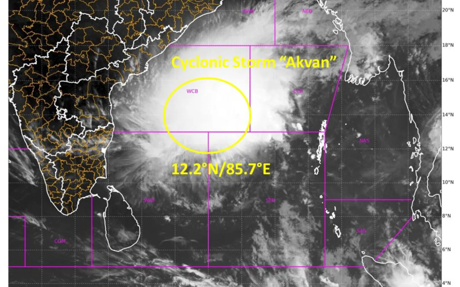
The India Meteorological Department (IMD) said Akvan would cross the north Andhra Pradesh and south Odisha coasts between Narsapur and Puri, close to east of Gopalpur, by noon on 20 November, with maximum sustained winds of 90 to 100 kmph gusting to 110 kmph. On the morning of 19 November, the storm lay centred near latitude 14.5 degrees North and longitude 85.3 degrees East, about 530 km south of Gopalpur.
Why does the Bay of Bengal spawn cyclones after the monsoon?
A cyclone needs an atmospheric disturbance, abundant moisture and favourable winds. The Bay has two main cyclone seasons, April to May and October to December. During the southwest monsoon, strong winds blowing in different directions at different heights suppress cyclone formation. But as the monsoon withdraws, the vertical wind shear weakens even as the waters remain warm, creating more favourable conditions.
The developing northeast monsoon also brings disturbances across the south of the Bay that help low-pressure systems build into cyclones.
A study published in May in the journal Scientific Reports found that there were around 1.8 cyclones a year in the post-monsoon period between 1982 and 2022, with the frequency increasing after 2001. The present succession is not common, but it is not unique either. The IMD has reported three cyclones within 32 days, all affecting Andhra Pradesh, in 1976 and 1987. In November 2013, Cyclones Helen and Lehar made landfall off the Andhra coast within a week of each other.
Did El Nino or the Indian Ocean Dipole cause the cluster?
The equatorial Pacific is currently in the throes of strong El Nino conditions. El Nino tends to reduce cyclone formation in the southern Bay of Bengal by weakening the winds that help storms rotate with more energy. Researchers from the Indian National Centre for Ocean Information Services in Hyderabad and Andhra University in Visakhapatnam found in a study published in March in Dynamics of Atmospheres and Oceans that El Nino's opposite phase, La Nina, generally favours cyclone formation in the Bay more.
The Indian Ocean Dipole, which describes a difference in sea temperatures between the western and eastern equatorial Indian Ocean, is currently neutral, according to the IMD, and that is not known to be specifically favourable for cyclones. A 2016 study in Atmospheric Science Letters reported that cyclones in October and November have been more strongly associated with variations in the Dipole than with an El Nino or a La Nina.
So the El Nino and Dipole conditions do not by themselves explain the three cyclones in the past month. That does not mean El Nino exerted no influence at all. The phenomenon also affects the winds that steer cyclones over the Bay of Bengal.
What role did the Madden-Julian Oscillation play?
The Madden-Julian Oscillation (MJO) could have proved a positive influence. The MJO is a large atmospheric disturbance that travels west to east through the tropics, increasing cloud formation and rainfall in a region over weeks. In its outlooks on 5 and 12 November, the IMD said the MJO was in a phase that favoured cyclone formation over the Bay and the Arabian Sea, and that this would persist for two weeks from 12 November.
The IMD has also said equatorial Rossby waves and Kelvin waves interacted with the MJO to push moist air upward over the southern and central Bay.
Why did Akvan move so slowly, and where did it go?
Akvan had been moving unusually slowly. While a slow-moving cyclone will spend more time over warm water and so be able to strengthen by drawing up more moisture, it will also stir the waters for longer, bringing cooler masses to the surface and reducing the heat available to power the storm. The IMD has acknowledged considerable disagreement between weather models about how Akvan's strength would change.
A 1991 study in the journal MAUSAM found that 87 percent of Bay cyclones in El Nino years between 1901 and 1987 crossed India south of 17 degrees North, over southern Andhra Pradesh and Tamil Nadu. A 2019 study in the International Journal of Climatology found cyclones were likelier to turn north or northeast during La Nina rather than El Nino years. Akvan, however, travelled mostly north, which the IMD said was due to an anticyclonic circulation over Myanmar and an approaching disturbance in the westerly winds.
Frequently Asked Questions
How many cyclones formed over the Bay of Bengal in the last month?
Three cyclones formed within 23 days: Arnab, which made landfall near Yanam on 28 October; Murasu, which made landfall near Ongole on 3 November; and Akvan, which made landfall near Gopalpur in Odisha on 20 November.
Is three cyclones in three weeks unusual for the Bay of Bengal?
It is uncommon but not unique. The IMD has reported three cyclones within 32 days in 1976 and 1987, and Cyclones Helen and Lehar made landfall off the Andhra coast within a week of each other in November 2013.
What is the Madden-Julian Oscillation, and why did it matter?
The Madden-Julian Oscillation is a large atmospheric disturbance that travels west to east through the tropics, increasing cloud formation and rainfall. In its November outlooks, the IMD said the oscillation was in a phase that favoured cyclone formation over the Bay of Bengal.
Read More: Explained: Why the Supreme Court Panel Wants Curbs on Riverbed Sand Mining
Read More: Core Sector Growth Hits Series-High 10.9% in October
Read More: Why India's Oil Import Bill Jumped 54% in Seven Months
Read More: NSE Becomes World's Fifth Largest Listed Exchange Operator


Comments
Be the first to comment on this story.